เมฆชั้นสูง, ทะเล, ภูเขา, ป่า
20 มิถุนายน 1998 13:59 UTC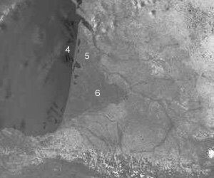
ภาพที่ตามองเห็นได้
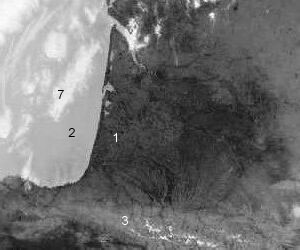
ภาพอินฟราเรด
ทางตะวันตกเฉียงใต้ของฝรั่งเศสในวันหนึ่งที่ร้อนของเดือนมิถุนายน. ในภาพอินฟราเรด, แผ่นดินที่ร้อน (1) จะปรากฏมืดมากในขณะที่ทะเล (2), ซึ่งเย็นว่า, จะสว่างกว่า. ที่ล่างสุดของภาพ เทือกเขาพิเรนีส (3) ก็สว่างกว่าที่ราบด้วย เพราะว่าพื้นนั้นร้อนน้อยกว่า. ในภาพที่มองเห็นได้, ทะเล (4) นั้นมืดกว่าแผ่นดิน (5), เพราะมันดูดกลืนการแผ่รังสีจากดวงอาทิตย์มากกว่า. ในลักษณะเดียวกัน, ป่าล็องด์ (Landes) (6) จึงปรากฏมืดกว่าบริเวณโดยรอบ. เมฆที่อยู่เหนือทะเล (7) เป็นสีขาวในภาพอินฟราเรด. ซึ่งหมายความว่ามันเย็น และดังนั้นมันจึงเป็นเมฆชั้นสูง. ในภาพที่ตามองเห็นได้ เมฆเหล่านี้เห็นได้ไม่ง่ายนัก มันเป็นเมฆที่บาง และเป็นไปได้ว่ามันน่าจะเป็นเมฆซีร์รัส.
ภาพที่ตามองเห็นได้
ภาพอินฟราเรด