เมฆคลื่น, เมฆฝนฟ้าคะนอง
17 พฤษภาคม 1999 18:18 UTC
ทางตอนใต้ของฝรั่งเศส. ตรงด้านขวาล่างสุดเป็นทะเลเมดิเตอร์เรเนียน. ความกดอากาศต่ำเหนือสเปนก่อให้เกิดลมแรงจากทิศใต้ไปตะวันออกเฉียงใต้เหนือเซเวน (Cévennes) (1), ซึ่งทำให้เกิดเมฆคลื่น. สิ่งนี้มองเห็นได้พร้อมกันทั้งภาพที่ตามองเห็นได้และภาพอินฟราเรด ในรูปร่างของแถบที่แยกออกจากกันเล็กน้อยสองแถบ (2). บนทางซ้ายของภาพ จะเห็นเมฆฝนฟ้าคะนองนั่นคือ เมฆคิวมูโลนิมบัส (3). จุดสีขาวเข้มในภาพอินฟราเรดนั้นเย็นมากเนื่องจากส่วนยอดของมันอยู่สูงมาก. เมฆเหล่านี้ซึ่งแผ่ขยายไปในแนวตั้งเป็นส่วนใหญ่นั้น จะมีเงา (4) ที่โดดเด่น ซึ่งสามารถเห็นได้ดีในภาพที่ตามองเห็นได้ ภายใต้แสงยามเย็นที่ส่องเป็นแนวทแยง.
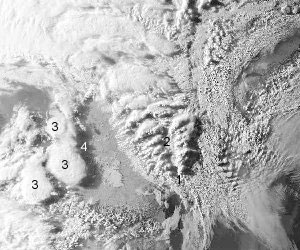
ภาพที่ตามองเห็นได้
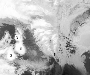
ภาพอินฟราเรด